
South Dakota is has quite an interesting geography. The state is separated into three separate regions which includes the Black Hills, Eastern South Dakota, and Western South Dakota. South Dakota has geographic features that vary from large plains, to big lakes, to large mountains and caves. South Dakota holds a few national parks and a state park. These parks include Windcave National Park, Badlands National Park, and Custer State Park.

Thunder Butte
The geographic formations found in South Dakota are known to contain pieces of Precambrian Granite that dates back to two billion years old. As well as there being granite that dates back to billions of years there have been discoveries found of glacial till that dates back to just a few million years. There is even rock deposit that only dates back to a few thousand years. There is evidence of a once ancient inland sea which once covered over most of western and central South Dakota. There is even evidence of sedimentary rocks found throughout the Black Hills which were created by marine skeletons settling and compacting into the ground. At about this same time 250 Million Years ago the Black Hills had an elevation of 15,000 Ft. but actually lost about 6,000 of rock layers because erosion took place in the area. These are reasons for the unique build of the Black Hill Mountain range. The fact that a sea was once in this area too has many influences on the area. The fact that this sea was here is the reason for the formation of Wind Cave National Park. The cave was formed by a complicated chemical change which occurred in the water. Sulfuric acid was formed and chemically combined with the water which overtime ate away at the limestone which is what started to form cave passageways. These cave passageways are dated back to starting to form 300 Million Years ago. Seas started to fill in the area and then continue to slowly move out again for the next 200 million years. The faster development of the cave is said to have happened over the past 100 years because of the newest Black Hills uplift.
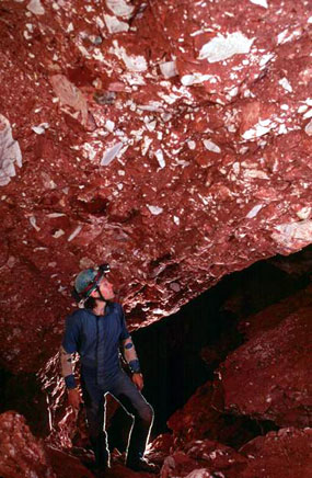
Wind Cave
South Dakota- 1,000 Years
In 1,000 years I believe south Dakota will be quite similar. The Black Hills mountain range may experience a start of some tectonic uplift along with erosion but nothing will be noticeable to the human eye. This is because mountains are always moving and breaking down and being formed in different ways. Tectonic plates are the reason for tectonic uplift and erosion is caused by factors such as wind and water flow which eats away at the rock.

South Dakota- 10,000 Years
In 10,000 Years there is a lot that could happen. I believe that tectonic uplift may be a little more apparent. There will definitely be the formation of new caves being formed along with the start of new possible mountains. Buttes which already exist now may increase in size. I also believe that other buttes will start to form. I predict there will also be a fair bit of erosion which will occur in the mountains of South Dakota.
South Dakota 1,000,000 Years
In 1 million years from now I believe that quite a fair bit will occur in South Dakota. I predict that much erosion will take place and a significant tectonic uplift will take place which will cause the formation of new lakes, new caves, new mountains, and an overall different landscape to South Dakota. Because of all the tectonic plate movement which is going to occur is going to have drastic effects on the continents. It is even possible that North America may split into 2. I believe that there will possibly be the formation of a new sea starting to form which will form in the Black Hills region. If in the past South Dakota had a sea due to plate tectonics and tectonic uplifts it is very possible that in the future this same kind of thing could happen again.
Sources:
